isardSAT has led the development of a new processor to retrieve coastal shorelines from Synthetic Aperture Radar (SAR) satellite data. This new product will help monitor coastal change in the UK and worldwide, regardless of the weather and the moment of the day.
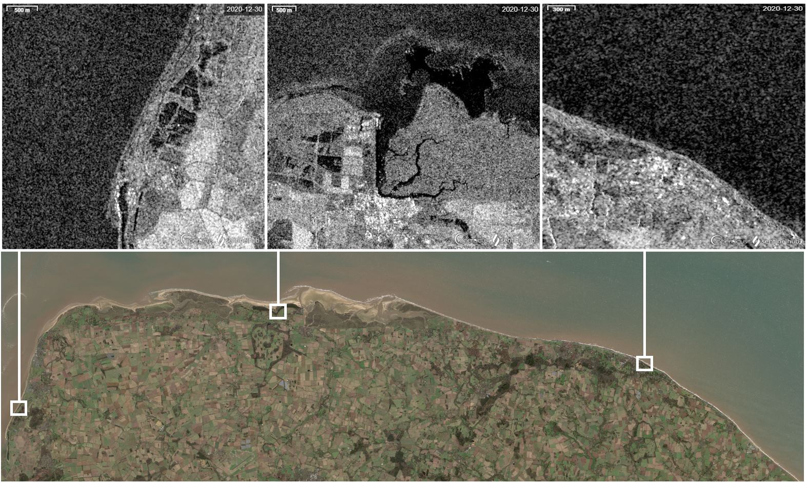 SAR images over the Norfolk coast © isardSAT
Coastal areas are especially vulnerable to climate change, not only because of floods and storms, but from erosion and rising sea level. Such factors put at risk the 11% of the world’s population, 896 million people who live near the oceans.
In the UK, current projections show the likely change in sea level to be between 0.27 and 1.12 meters by the end of the century. However, most of the highly populated coastal cities are in the Southern Hemisphere, where Earth Observation data is not always available.
SAR data: observing the coastline through the clouds, anytime
Coastal change has frequently been monitored with optical images, which are subject to the effect of tides. Satellites can register different waterlines for the same segment of coast depending on the moment they pass by, hampering the definition of the shoreline.
A new paper led by isardSAT shows successful results of a SAR shoreline processor to pinpoint the actual shoreline from different satellite acquisitions. SAR is a microwave technology able to retrieve Earth’s surface features all around the globe, regardless of the weather conditions or the light present. The processor, developed with the Hydraulic Institute of Cantabria, the British Geological Survey, the Maynooth University, and the Geological Survey of Ireland, shows especially good results in flat beaches.
Bull Island: monitoring a vanishing beach
One example of flat beach analysed is the one in Bull Island (Ireland), where the shoreline profile obtained is in very strong agreement with the data from Digital Shoreline Analysis System (DSAS). The latter is a robust tool designed by the United States Geological Survey (USGS), commonly used in the area, and it is based on an optical evaluation of the vegetation line over time.
SAR shoreline processor’s outcome over Bull Island confirms the alarming trend of the coast’s regression, reaching 10 m per year in some areas. In other words, within the timespan of the dataset used (2016 to 2022), some areas of the island lost up to 60 meters of surface width.
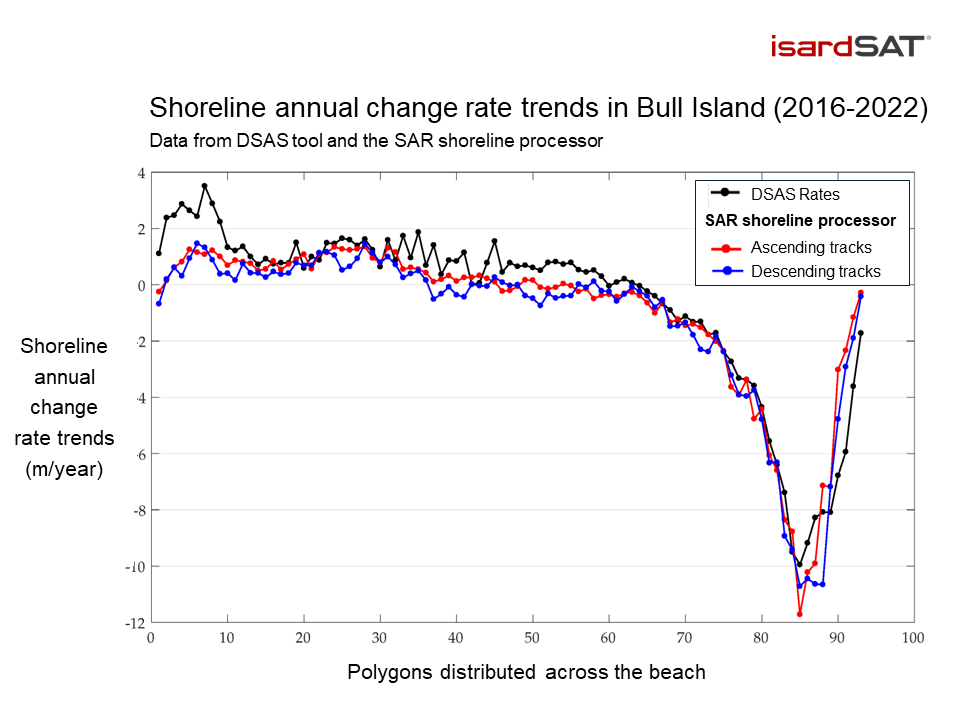 Comparison of shoreline annual change rate trends (m/year) detected by DSAS tool (black) and the SAR processor developed by isardSAT (red and blue). The profile shows very strong agreement in the change rates, both for the processor’s ascending and descending tracks. © isardSAT
Understanding coastal dynamics
Beyond detecting the shoreline, the processor has been able to identify coastal dynamics in some locations studied. It is the case of Start Bay (England), where the results showed the seasonal rotation of the beach. In Salinas beach (Spain), the data from the processor provided for the first time an approach to capitalise patterns of shore change caused by hydrodynamics.
“There’s some scepticism in associating coastal monitoring with SAR, favouring optical technology analysis instead”, explains Salvatore Savastano, lead author of the study. “However, SAR has great potential, and allows us to detect surface features that optical sensors cannot capture. We are working to capitalise on the benefits of this technology as much as possible, improving our product even in more complex scenarios, which will expand its applicability”, adds Savastano.
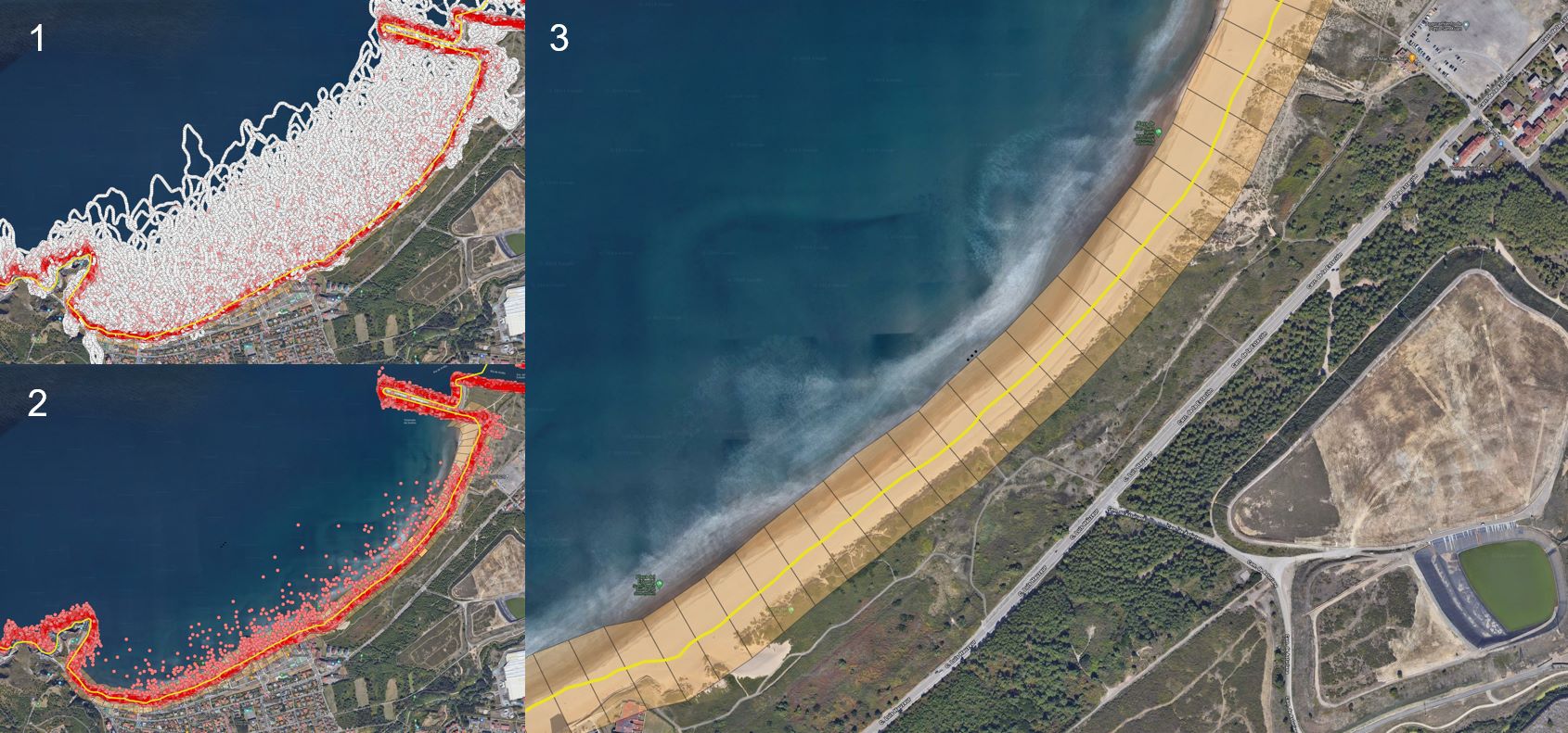 In Salinas beach (Spain), shoreline was identified by filtering all the shoreline points detected (1 to 2), and creating polygons from the shoreline definition. © isardSAT, Google Earth.
Monitoring the shoreline in the UK and worldwide
isardSAT is currently involved in two UK-based projects that will serve as an opportunity to implement and improve this SAR processor for coastal monitoring. In the UK Gravel Barriers initiative, led by the British Geological Survey, the shoreline processor will be used to generate an historical dataset of coastal change. This information will be key to characterise multi-hazards on gravel barrier coasts, improving the understanding and modelling capability of gravel barrier systems in the British coasts.
The other one is A Global Shoreline Capability, funded by the UK Space Agency and led by Argans Ltd. This project aims at developing a shoreline data processor that is applicable globally to improve coastal management plans worldwide, enabling nations with very limited amounts of current or historical geospatial data to generate their own coastal indicators.
This project will use SAR data to build a Digital Terrain Model (DTM) to complement optical images. This tool will substitute current DTMs based on Light Detection and Ranging models (LiDAR), which are provided by the European Environment Agency (EEA) and have geographical limitations – especially in the Southern Hemisphere.
The processor’s data is also in use and being validated against optical data in the Climate Impetus project by Lobelia Earth. This case study will assess the impact of coastal erosion in Catalonia by establishing a consistent time and spatial coverage of the coast, and determining the areas most vulnerable to erosion.
Reference:
Savastano, S.; Gomes da Silva, P.; Sánchez, J.M.; Tort, A.G.; Payo, A.; Pattle, M.E.; Garcia-Mondéjar, A.; Castillo, Y.; Monteys, X. Assessment of Shoreline Change from SAR Satellite Imagery in Three Tidally Controlled Coastal Environments. J. Mar. Sci. Eng. 2024, 12, 163. https://doi.org/10.3390/jmse12010163